
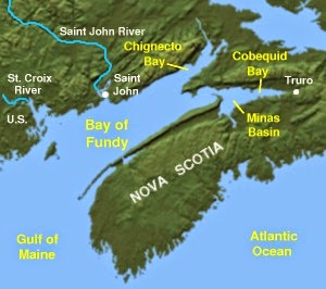
The Bay of Fundy is home to our planet's most extreme tides. At high tide (see above), it reaches up to about 55 feet at its innermost point in the Minas Basin (see the map below).
At low tide—which happens twice every day—the water laps back and back toward the Gulf of Maine. As it goes, it leaves snails,

fishing boats,

and even islands stranded in the thick red limestone muck that lies at its bottom.

Why are the tides here so high? It's because of something called tidal resonance. Have a look at the map again. Imagine you are tilting it so the water flows out of the Bay, toward the Gulf. The time it takes for that giant wave of water you'd create to flow all the way out, then all the way back, coincides perfectly with the tides of the Atlantic Ocean. The Atlantic's high tide gives the water in the Bay a big push as it surges back in. Then the water gets squeezed up and up as it enters the narrow Minas Basin and approaches Burntcoat Head, where the very highest tides have been recorded. That's Burncoat Head beach in the photo above—two whole hours before dead low tide!
Stay tuned for a full episode about an amazing feature of the Bay of Fundy's tides, coming soon!
So, it's like a giant bathtub, right?!
ReplyDeleteA giant tilting, tidal bathtub, filled with whales & sharks!!
ReplyDelete